Peru (Republic of Peru)
 |
 |
| Flag of Peru | |
Peruvian territory was home to several cultures during the ancient and medieval periods, and has one of the longest histories of civilization of any country, tracing its heritage back to the 10th millennium BCE. Notable pre-colonial cultures and civilizations include the Caral-Supe civilization (the earliest civilization in the Americas and considered one of the cradles of civilization), the Nazca culture, the Wari and Tiwanaku empires, the Kingdom of Cusco, and the Inca Empire, the largest known state in the pre-Columbian Americas.
The Spanish Empire conquered the region in the 16th century and Charles V established a viceroyalty with the official name of the Kingdom of Peru that encompassed most of its South American territories, with its capital in Lima. Higher education started in the Americas with the official establishment of the National University of San Marcos in Lima in 1551. Peru formally proclaimed independence in 1821, and following the foreign military campaigns of José de San Martín and Simón Bolívar, and the decisive battle of Ayacucho, Peru completed its independence in 1824. In the ensuing years, the country first suffered from political instability until a period of relative economic and political stability began due to the exploitation of guano that ended with the War of the Pacific (1879–1884). In the 20th century, the country endured coups, social unrest, and internal conflicts, as well as periods of stability and economic upswing. In the 1990s, the country implemented a neoliberal economic model under Alberto Fujimori, with his political ideology of Fujimorism encompassing the governance of Peru into the present day through a cult of personality. As the 2000s commodities boom took place, Peru experienced a period of constant economic growth and a decrease in poverty. Through the 2010s and into the 2020s, political crises and the COVID-19 pandemic in Peru revealed long existing vulnerabilities of the nation's lack of political function and the inability to provide social services for its citizens, with unrest beginning into 2023 raising concerns of political leaders in Lima seeking a more authoritarian government. Broadly interpreted impeachment wording in the 1993 Constitution of Peru and a February 2023 ruling by the Constitutional Court of Peru has essentially given Congress absolute control of Peru's government.
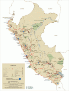
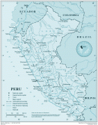
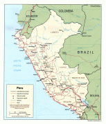
The sovereign state of Peru is a representative democratic republic divided into 25 regions. Its main economic activities include mining, manufacturing, agriculture and fishing, along with other growing sectors such as telecommunications and biotechnology. The country forms part of The Pacific Pumas, a political and economic grouping of countries along Latin America's Pacific coast that share common trends of positive growth, stable macroeconomic foundations, improved governance and an openness to global integration. Peru ranks high in social freedom; it is an active member of the Asia-Pacific Economic Cooperation, the Pacific Alliance, the Comprehensive and Progressive Agreement for Trans-Pacific Partnership and the World Trade Organization; and is considered as a middle power.
Peru has a population that includes Mestizos, Amerindians, Europeans, Africans and Asians. The main spoken language is Spanish, although a significant number of Peruvians speak Quechuan languages, Aymara, or other Indigenous languages. This mixture of cultural traditions has resulted in a wide diversity of expressions in fields such as art, cuisine, literature, and music.
The name of the country may be derived from Birú, the name of a local ruler who lived near the Bay of San Miguel, Panama City, in the early 16th century. Spanish conquistadors, who arrived in 1522, believed this was the southernmost part of the New World. When Francisco Pizarro invaded the regions farther south, they came to be designated Birú or Perú.
An alternative history is provided by the contemporary writer Inca Garcilaso de la Vega, son of an Inca princess and a conquistador. He said the name Birú was that of a common Amerindian who was happened upon by the crew of a ship on an exploratory mission for governor Pedro Arias Dávila and went on to relate more instances of misunderstandings due to the lack of a common language.
The Spanish Crown gave the name legal status with the 1529 Capitulación de Toledo, which designated the newly encountered Inca Empire as the province of Peru. In 1561, the rebel Lope de Aguirre declared himself the "Prince" of an independent Peru, which was cut short by his arrest and execution. Under Spanish rule, the country adopted the denomination Viceroyalty of Peru, which became the Peruvian Republic after its independence until 1979, adopting its current name of Republic of Peru.
Currency / Language
| ISO | Currency | Symbol | Significant figures |
|---|---|---|---|
| PEN | Peruvian sol | S/ | 2 |
| ISO | Language |
|---|---|
| AY | Aymara language |
| QU | Quechua language |
| ES | Spanish language |