Midi-Pyrénées
 |
Midi-Pyrénées has no historical or geographical unity. It is one of the regions of France created in the late 20th century to serve as a hinterland and zone of influence for its capital, Toulouse, one of a handful of so-called "balancing metropolises" (métropoles d'équilibre). Another example of this is the region of Rhône-Alpes which was created as the region for Lyon.
Historically, Midi-Pyrénées is made up of several former French provinces:
* 24.2% of the Midi-Pyrénées territory formed part of Gascony: western half of Haute-Garonne department, southwest of Tarn-et-Garonne, Gers in its entirety, extreme north of Hautes-Pyrénées. Gascony here includes the province of Comminges, which historically was a Pyrenean province, but later expanded all the way north to Muret in the southern suburbs of Toulouse, then was fragmented, and became an eastern fringe of Gascony. Gascony also extends over the Aquitaine region.
* 23.4% of Midi-Pyrénées was part of Languedoc: the eastern half of Haute-Garonne, southeast of Tarn-et-Garonne, Tarn in its entirety, northwest and northeast of Ariège. Languedoc includes the sub-province of Albigeois (Tarn department), which is sometimes considered as a province separate from Languedoc. Languedoc also extends over the Languedoc-Roussillon region.
* 19.9% of Midi-Pyrénées was formerly Rouergue: Aveyron department in its entirety, and extreme east of Tarn-et-Garonne. The former province of Rouergue lay entirely within the modern Midi-Pyrénées.
* 15.4% of Midi-Pyrénées was Quercy: department of Lot in its entirety, and northern half of Tarn-et-Garonne. The province of Quercy was entirely contained inside Midi-Pyrénées.
* 16.6% of Midi-Pyrénées was a collection of small Pyrenean provinces, from east to west: the County of Foix (eastern half of Ariège), Couserans (western half of Ariège), Nébouzan (extreme south of Haute-Garonne and extreme east of Hautes-Pyrénées), Quatre-Vallées (i.e. "Four Valleys") (east of Hautes-Pyrénées), and Bigorre (west and center of Hautes-Pyrénées). All these provinces are entirely contained inside Midi-Pyrénées.
* 0.5% of Midi-Pyrénées is Agenais: extreme west of Tarn-et-Garonne. Agenais extends essentially over the Aquitaine region.
The historical makeup of Midi-Pyrénées is even more complex, as the provinces listed here are further subdivided into pays–used interchangeably in French for country, area, land, etc.–each with its own particular identity, such as Armagnac, Astarac, or Lomagne inside the Gascogne part of Midi-Pyrénées, Lauragais or Volvestre inside the Languedoc part of Midi-Pyrénées, Bonezan inside County of Foix, Lavedan inside Bigorre, and so on.
Map - Midi-Pyrénées
Map


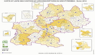

Country - France
 |
 |
| Flag of France | |
Inhabited since the Palaeolithic era, the territory of Metropolitan France was settled by Celtic tribes known as Gauls during the Iron Age. Rome annexed the area in 51 BC, leading to a distinct Gallo-Roman culture that laid the foundation of the French language. The Germanic Franks formed the Kingdom of Francia, which became the heartland of the Carolingian Empire. The Treaty of Verdun of 843 partitioned the empire, with West Francia becoming the Kingdom of France in 987. In the High Middle Ages, France was a powerful but highly decentralised feudal kingdom. Philip II successfully strengthened royal power and defeated his rivals to double the size of the crown lands; by the end of his reign, France had emerged as the most powerful state in Europe. From the mid-14th to the mid-15th century, France was plunged into a series of dynastic conflicts involving England, collectively known as the Hundred Years' War, and a distinct French identity emerged as a result. The French Renaissance saw art and culture flourish, conflict with the House of Habsburg, and the establishment of a global colonial empire, which by the 20th century would become the second-largest in the world. The second half of the 16th century was dominated by religious civil wars between Catholics and Huguenots that severely weakened the country. France again emerged as Europe's dominant power in the 17th century under Louis XIV following the Thirty Years' War. Inadequate economic policies, inequitable taxes and frequent wars (notably a defeat in the Seven Years' War and costly involvement in the American War of Independence) left the kingdom in a precarious economic situation by the end of the 18th century. This precipitated the French Revolution of 1789, which overthrew the Ancien Régime and produced the Declaration of the Rights of Man, which expresses the nation's ideals to this day.
Currency / Language
| ISO | Currency | Symbol | Significant figures |
|---|---|---|---|
| EUR | Euro | € | 2 |
| ISO | Language |
|---|---|
| EU | Basque language |
| BR | Breton language |
| CA | Catalan language |
| CO | Corsican language |
| FR | French language |
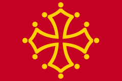
| OC | Occitan language |