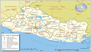
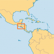
El Salvador (Republic of El Salvador)
 |
 |
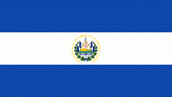
| Flag of El Salvador | |
Among the Mesoamerican nations that historically controlled the region are the Lenca (after 600 AD), the Mayans, and then the Cuzcatlecs. Archaeological monuments also suggest an early Olmec presence around the first millennium BC. In the beginning of the 16th century, the Spanish Empire conquered the Central American territory, incorporating it into the Viceroyalty of New Spain ruled from Mexico City. However the Viceroyalty of New Spain had little to no influence in the daily affairs of the isthmus, which was colonized in 1524. In 1609, the area was declared the Captaincy General of Guatemala by the Spanish, which included the territory that would become El Salvador until its independence from Spain in 1821. It was forcibly incorporated into the First Mexican Empire, then seceded, joining the Federal Republic of Central America in 1823. When the federation dissolved in 1841, El Salvador became a sovereign state, then formed a short-lived union with Honduras and Nicaragua called the Greater Republic of Central America, which lasted from 1895 to 1898.
From the late 19th to the mid-20th century, El Salvador endured chronic political and economic instability characterized by coups, revolts, and a succession of authoritarian rulers. Persistent socioeconomic inequality and civil unrest culminated in the Salvadoran Civil War from 1979 to 1992, fought between the military-led government backed by the United States, and a coalition of left-wing guerrilla groups. The conflict ended with the Chapultepec Peace Accords. This negotiated settlement established a multiparty constitutional republic, which remains in place to this day.
During the civil war, large numbers of Salvadorans emigrated to the United States. By 2008, they were one of the largest immigrant groups in the US.
El Salvador's economy has historically been dominated by agriculture, beginning with the Spanish taking control of the indigenous cacao crop in the 16th century, with production centered in Izalco, along with balsam from the ranges of La Libertad and Ahuachapan. This was followed by a boom in use of the indigo plant in the 19th century, mainly for its use as a dye. Thereafter the focus shifted to coffee, which by the early 20th century accounted for 90% of export earnings. El Salvador has since reduced its dependence on coffee and embarked on diversifying its economy by opening up trade and financial links and expanding the manufacturing sector. The colón, the currency of El Salvador since 1892, was replaced by the United States dollar in 2001. El Salvador ranks 124th among 189 countries in the Human Development Index. As of 2019 economic improvements had led to El Salvador experiencing the lowest level of income inequality among countries in Latin America and the Caribbean. Among 77 countries included in a 2021 study, El Salvador had one of the least complex economies for doing business.
Conquistador Pedro de Alvarado named the new province after Jesus Christ – San Salvador (lit. "Holy Savior"). The territory's name, including the province of San Miguel, was later extended to the Provincia De Nuestro Señor Jesus Cristo, El Salvador Del Mundo, shortened to the Republic of El Salvador, or Salvador, during the post-Federal Republic period and subsequently settled on as El Salvador.
Currency / Language
| ISO | Currency | Symbol | Significant figures |
|---|---|---|---|
| SVC | Salvadoran colón | 2 | |
| USD | United States dollar | $ | 2 |
| ISO | Language |
|---|---|
| ES | Spanish language |