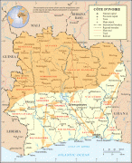
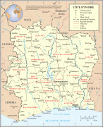
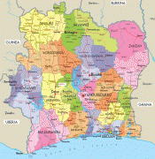
Côte d'Ivoire (Republic of Côte d’Ivoire)
 |
 |
| Flag of Ivory Coast | |
Before its colonization by Europeans, Ivory Coast was home to several states, including Gyaaman, the Kong Empire, and Baoulé. The area became a protectorate of France in 1843 and was consolidated as a French colony in 1893 amid the European Scramble for Africa. It achieved independence in 1960, led by Félix Houphouët-Boigny, who ruled the country until 1993. Relatively stable by regional standards, Ivory Coast established close political-economic ties with its West African neighbours while maintaining close relations with the West, especially France. Its stability was diminished by a coup d'état in 1999, then two civil wars—first between 2002 and 2007 and again during 2010–2011. It adopted a new constitution in 2016.
Ivory Coast is a republic with strong executive power vested in its president. Through the production of coffee and cocoa, it was an economic powerhouse in West Africa during the 1960s and 1970s, then experienced an economic crisis in the 1980s, contributing to a period of political and social turmoil that extended until 2011. Ivory Coast has experienced again high economic growth since the return of peace and political stability in 2011. From 2012 to 2021, the economy grew by an average of 7.4% per year in real terms, the second-fastest rate of economic growth in Africa and fourth-fastest rate in the world. In 2020, Ivory Coast was the world's largest exporter of cocoa beans and had high levels of income for its region. In the 21st century, the economy still relies heavily on agriculture, with smallholder cash-crop production predominating.
Originally, Portuguese and French merchant-explorers in the 15th and 16th centuries divided the west coast of Africa, very roughly, into four "coasts" reflecting resources available from each coast. The coast that the French named the Côte d'Ivoire and the Portuguese named the Costa do Marfim—both meaning "Coast of Ivory"—lay between what was known as the Guiné de Cabo Verde, so-called "Upper Guinea" at Cap-Vert, and Lower Guinea. There was also a Pepper Coast, also known as the "Grain Coast" (present-day Liberia), a "Gold Coast" (Ghana), and a "Slave Coast" (Togo, Benin and Nigeria). Like those, the name "Ivory Coast" reflected the major trade that occurred on that particular stretch of the coast: the export of ivory.
Other names for the area included the Côte de Dents, literally "Coast of Teeth", again reflecting the ivory trade; the Côte de Quaqua, after the people whom the Dutch named the Quaqua (alternatively Kwa Kwa); the Coast of the Five and Six Stripes, after a type of cotton fabric also traded there; and the Côte du Vent, the Windward Coast, after perennial local off-shore weather conditions. In the 19th century, usage switched to Côte d'Ivoire.
The coastline of the modern state is not quite coterminous with what the 15th- and 16th-century merchants knew as the "Teeth" or "Ivory" coast, which was considered to stretch from Cape Palmas to Cape Three Points and which is thus now divided between the modern states of Ghana and Ivory Coast (with a minute portion of Liberia). It retained the name through French rule and independence in 1960. The name had long since been translated literally into other languages, which the post-independence government considered increasingly troublesome whenever its international dealings extended beyond the Francophone sphere. Therefore, in April 1986, the government declared that Côte d'Ivoire (or, more fully, République de Côte d'Ivoire) would be its formal name for the purposes of diplomatic protocol and has since officially refused to recognize any translations from French to other languages in its international dealings. Despite the Ivorian government's request, the English translation "Ivory Coast" (often "the Ivory Coast") is still frequently used in English by various media outlets and publications.
Currency / Language
| ISO | Currency | Symbol | Significant figures |
|---|---|---|---|
| XOF | West African CFA franc | Fr | 0 |
| ISO | Language |
|---|---|
| FR | French language |