Savanes Region (Savanes)
Savanes is divided into the prefectures of Kpendjal, Oti, Tandjouaré, and Tône.
To the south of Savanes is Kara Region, its only domestic border. It shares borders with the following foreign areas: Savanes is the only region that borders Burkina Faso.
* Northern Region, Ghana: southwest
* Upper East Region, Ghana: west
* Boulgou Province, Burkina Faso: far northwest
* Koulpélogo Province, Burkina Faso: northwest
* Kompienga Province, Burkina Faso: northeast
* Atakora Department, Benin: east
* Regions of Togo
Map - Savanes Region (Savanes)
Map


Country - Togo
 |
 |
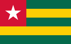
| Flag of Togo | |
Various people groups settled the boundaries of present day Togo between the 11th to 16th centuries. Between the 16th and 18th centuries, the coastal region served primarily as a European slave trading outpost, earning Togo and the surrounding region the name "The Slave Coast". In 1884, Germany declared a region including a protectorate called Togoland. After World War I, rule over Togo was transferred to France. Togo gained its independence from France in 1960. In 1967, Gnassingbé Eyadéma led a successful military coup d'état, after which he became president of an anti-communist, single-party state. In 1993, Eyadéma faced multiparty elections marred by irregularities, and won the presidency three times. At the time of his death, Eyadéma was the "longest-serving leader in modern African history", having been president for 38 years. In 2005, his son Faure Gnassingbé was elected president.
Currency / Language
| ISO | Currency | Symbol | Significant figures |
|---|---|---|---|
| XOF | West African CFA franc | Fr | 0 |
| ISO | Language |
|---|---|
| EE | Ewe language |
| FR | French language |
| HA | Hausa language |