Ninoy Aquino International Airport (Ninoy Aquino Manila International Airport)
Ninoy Aquino International Airport (NAIA, locally ; Paliparang Pandaigdig ng Ninoy Aquino; ), originally known as Manila International Airport (MIA), is the main international airport serving the city of Manila and the metropolitan area of the same name. Located between the cities of Pasay and Parañaque, about 7 km south of Manila proper and southwest of Makati, NAIA is the main gateway for travelers to the Philippines and serves as a hub for AirSWIFT, Cebgo, Cebu Pacific, PAL Express, and Philippine Airlines; it is also the main operating base for Philippines AirAsia. Named after Senator Ninoy Aquino (1932–1983), who was assassinated at the airport on August 21, 1983, it is managed by the Manila International Airport Authority (MIAA), an agency of the Department of Transportation (DOTr).
Officially, NAIA is the only airport serving the Metro Manila area. However, in practice, both NAIA and Clark International Airport, located in the Clark Freeport Zone in Pampanga, serve the metropolis. However, Clark caters mostly to low-cost carriers because of its lower landing fees compared to the higher fees at NAIA. Recently, there have been calls for Clark to replace NAIA eventually as the primary airport of the Philippines. In an effort to reduce congestion at the airport, two new airports are being constructed: New Manila International Airport, located in Bulacan, and Sangley Point Airport, located on reclaimed land in Cavite City.
Currently, NAIA is operating beyond its designed capacity of 35 million passengers, causing air traffic congestion and flight delays. The airport has been tagged by The Guide to Sleeping In Airports, luggage storage app Bounce , and travel blog Hawaiian Islands as one of the worst airports in both Asia-Pacific, if not the world. Since 2018, plans to privatize and improve the airport have been pitched, and were revived again in 2023 following a major malfunction in the airport's air traffic control system.
Map - Ninoy Aquino International Airport (Ninoy Aquino Manila International Airport)
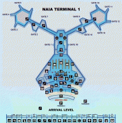
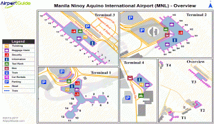
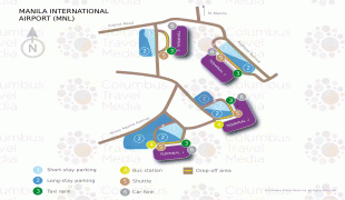
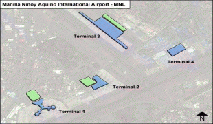
Map


Country - Philippines
 |
 |
| Flag of the Philippines | |
Negritos, some of the archipelago's earliest inhabitants, were followed by successive waves of Austronesian peoples. Adoption of animism, Hinduism and Islam established island-kingdoms called Kedatuan, Rajahnates, and Sultanates. The arrival of Ferdinand Magellan, a Portuguese explorer leading a fleet for Spain, marked the beginning of Spanish colonization. In 1543, Spanish explorer Ruy López de Villalobos named the archipelago Las Islas Filipinas in honor of Philip II of Spain. Spanish settlement through Mexico, beginning in 1565, led to the Philippines becoming ruled by the Spanish Empire for more than 300 years. During this time, Catholicism became the dominant religion, and Manila became the western hub of trans-Pacific trade. In 1896, the Philippine Revolution began, which then became entwined with the 1898 Spanish–American War. Spain ceded the territory to the United States, while Filipino revolutionaries declared the First Philippine Republic. The ensuing Philippine–American War ended with the United States establishing control over the territory, which they maintained until the Japanese invasion of the islands during World War II. Following liberation, the Philippines became independent in 1946. Since then, the unitary sovereign state has often had a tumultuous experience with democracy, which included the overthrow of a decades-long dictatorship by a nonviolent revolution.
Currency / Language
| ISO | Currency | Symbol | Significant figures |
|---|---|---|---|
| PHP | Philippine peso | ₱ | 2 |
| ISO | Language |
|---|---|
| EN | English language |
| TL | Tagalog language |